Getting to the Pine Grove
For the health and sustainability of our gatherings, it is important that we, as individuals and family units, be pro-active about organizing ride-shares/car-pools, sorting out our own navigation, and finding our way to the Pine Grove. We have included multiple sets of directions below, from multiple directions of origin. If you still are having difficulty understanding how to get to the gathering you can email our Transportation Maestros, at getmetothegathering@big-heart-circle.org. Also if you will be traveling by car, and will have extra seats for carpools, please send an email to let us know in case you can help someone make it to the gathering.
Note to Drivers: We try to be environmentally responsible in all areas of life. If you have never been to the Pine Grove, or are not 100% comfortable with the directions, please print them out and carry them with you.
Part of this Gathering is about being “off the grid”. We are going into the Woods. This impacts GPS & cell service. It’s better to plan ahead so you will enjoy the experience and ceremony.
Coordinating ride-shares: We’ve set up a simple spreadsheet to help pair up people-with-empty-seats-in-their-cars and people-looking-for-a-ride. If you happen to be either someone who is looking for a ride or someone who has extra room in your vehicle, please consider putting in your info on this sheet. There are tabs at the bottom to select which day is relevant to the ride you are seeking or offering. Dori (dcocoros@gmail.com) will be keeping on eye on the sheet and helping to make connections. If you’re coming into the Kingston Bus Station we can arrange for someone from the gathering to come pick you up.
[Click here to check out the ride-share sheet]
If you plan on taking a train you are responsible for coordinating your own pick-up and ride to the Pine Grove. You will most likely want to take the Amtrak to Rhinecliff.
If you plan on taking the bus we may be cultivating a few scheduled shuttle runs to the Kingston bus station. You should notify our Transportation Maestro, at getmetothegathering@big-heart-circle.org so he can begin cultivating a pick-up schedule. You will want to take the Adirondack Trailways Bus system: http://www.trailwaysny.com/
 Directions to the Pine Grove from New York City:
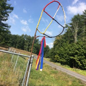
The picture at left is of our medicine wheel, which will be hung at the entrance to the Pine Grove off Route 28-A. Look for the medicine wheel so you know you are entering the Pine Grove.
Please also note that as part of our agreement with the property owners, we have been asked to stay in the Pine Grove section of the property throughout the weekend. This means we are not to drive or hike to other areas of the property. Please also note that the Pine Grove does not have a mailing address attached to it. It is in a wooded camping area. If you have never been to the Pine Grove or are not familiar with the area, please consider printing out the instructions and taking them with you, as cell and GPS reception in the area can be spotty.
NOTE: The map below shows you the entrance to the Pine Grove camping area off of Route 28-A.
NY: Directions to the Pine Grove:
Take Kingston Exit 19 from Thruway (I-87) and follow the sign to Route 28 West / Pine Hill (quick right after the toll).
If coming from Ellenville or Rhinebeck, go west at the cloverleaf intersection of Routes 209 and 28.
Continue on Route 28 West for 11.5 miles to the hamlet of Shokan. Turn left at Winchell’s Pizza (red building on left) onto Reservoir Road. (Also, an arrow sign on your right for “Olivebridge 4 Miles” points left for Reservoir Road.) Cross the Ashokan Reservoir Bridge and continue to the stop sign.Turn left at the stop sign onto Monument Road. This is just after passing between stone buildings on the bridge. This road bears downhill to the right and by staying to the right you will merge with route 28A. On Route 28A, one mile past the group of buildings that are the administration and maintenance buildings for the Ashokan Reservoir you will see a gate into a small meadow on the left side of the road and signs for the gathering. Turn into the meadow and drive into the woods on the far side of the meadow. Please go directly to the registration tent to sign in.
MORE DETAILED DIRECTIONS TO THE PINE GROVE
Via the NYS Thruway
Take Kingston Exit 19 and follow the sign to Route 28 West / Pine Hill (quick right after the toll).
Continue on Route 28 West for 11.5 miles to the hamlet of Shokan.
Turn left at Winchell’s Pizza (red building on left) onto Reservoir Road. (Also, an arrow sign on your right for “Olivebridge 4 Miles” points left for Reservoir Road.)
Cross the Ashokan Reservoir Bridge and continue to the stop sign.
Turn left at the stop sign onto Monument Road.
Bear right at the fork onto 28A. On Route 28A, one mile past the group of buildings that are the administration and maintenance buildings for the Ashokan Reservoir you will see a gate into a small meadow on the left side of the road and signs for the gathering. Turn into the meadow and drive into the woods on the far side of the meadow. Please go directly to the registration tent to sign in.
From Ellenville via Route 209
Traveling north on 209, turn left in the village of Stone Ridge onto NY 213. (This is an easily-missed turn – look very closely for the 213 sign.)
Stay on 213, following signs to Olivebridge, until it ends at a stop sign.
Turn right on Route 28-A. About a half mile down on the right, you will see a gate into a small meadow and signs for the gathering. Turn into the meadow and drive into the woods on the far side of the meadow. Please go directly to the registration tent to sign in. If you reach the maintenance buildings for the Reservoir, you have gone too far on Route 28-A.
From Oneonta
Take Route 28 East.
Pass signs for Phoenicia and Mt. Tremper – and go through the village of Boiceville.
Approximately 2 miles past the sign for Shokan, turn right onto Reservoir Road at the sign for “Olivebridge 4-miles. ” (Also, the stores “Moose Crossing” and “Winchell’s Antiques” are on the corner, on your right.)
Cross the Ashokan Reservoir Bridge and continue to the stop sign.
Turn left at the stop sign onto Monument Road.
Bear right at the fork onto 28A. On Route 28A, one mile past the group of buildings that are the administration and maintenance buildings for the Ashokan Reservoir you will see a gate into a small meadow on the left side of the road and signs for the gathering. Turn into the meadow and drive into the woods on the far side of the meadow. Please go directly to the registration tent to sign in.
From the Kingston-Rhinecliff Bridge
Continue off the bridge (Rt. 199 becomes Rt. 209)
for approximately six miles.
Take the Route 28-West / Pine Hill Exit.
Continue on Route 28-West to the hamlet of Shokan.
Turn left at Winchell’s Pizza (red building on left) onto Reservoir Road. (Also, an arrow sign on your right for “Olivebridge 4 Miles” points left for Reservoir Road.)
Cross the Ashokan Reservoir Bridge and continue to the stop sign.
Turn left at the stop sign onto Monument Road.
Bear right at the fork onto 28A. On Route 28A, one mile past the group of buildings that are the administration and maintenance buildings for the Ashokan Reservoir you will see a gate into a small meadow on the left side of the road and signs for the gathering. Turn into the meadow and drive into the woods on the far side of the meadow. Please go directly to the registration tent to sign in.
